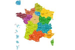
New map of France reduces regions to 13

A new map of France reorganised its internal administration, reducing the number of regions from 22 down to 13. After months of debate, resistance, changes, and much reshuffling of cartography, the 13-region version was adopted by the Assemblée Nationale – the lower house of the bicameral Parliament of France – with effect in January 2016 with the aim to simplify bureaucracy and save costs.
Until December 2015, the country was previously divided into 22 administrative regions, which in turn are divided into departments. These political and administrative borders are not to be confused with the historical or cultural regions of France, which have and preserve their own character, architecture, traditions, geography, cuisine and even their singular dialects.
The French state is decentralised territorially in order to coordinate and deliver state functions more effectively. While French regions do not hold legislative authority – they do not write their own laws – they do indeed have considerable discretionary power over infrastructure and operational spending in education, tourism, public transit, universities and research, unemployment, and assistance to businesses.
[mrb]
What changes?
Of the new 13 regions in the new map of France, only seven experienced changes to the previously existing distribution.
The regions that changed are:
- Grand-Est (Alsace, Champagne-Ardenne and Lorraine)
- Nouvelle-Aquitaine (Aquitaine, Limousin and Poitou-Charentes)
- Auvergne-Rhône-Alpes
- Bourgogne-Franche-Comté
- Occitanie (Languedoc-Roussillon and Midi-Pyrénées)
- Hauts-de-France (combining Nord-Pas-de-Calais and Picardie)
- Normandie (combining Basse-Normandie and Haute-Normandie)
The other 6 regions stay just as they were before:
- Bretagne
- Corse
- Centre
- Île-de-France
- Pays de la Loire
- Provence-Alpes-Côte d’Azur
REGIONAL CAPITALS
The discussion now shifts to which city will become the capital of the new regions (Strasbourg has already been identifed as the capital of the Alsace/Champagne-Ardenne/Lorraine region) and what happens to the public servants currently employed at the regional level. It will make for interesting conversation, to say the least, as the regions that blend into one will have a considerable overlap of administrative functions.
Confirmed capitals:
Rennes: Bretagne (region unchanged)
Ajaccio: Corse (region unchanged)
Orleans: Centre (region unchanged)
Paris: Île-de-France (region unchanged)
Nantes: Pays de la Loire (region unchanged)
Marseille: Provence-Alpes-Côte d’Azur (region unchanged)
Strasbourg: Alsace-Champagne-Ardenne-Lorraine (new regional capital designated by decree on January 16, 2015)
Provisional capitals:
The list of new regional capital will be firmed up in July 2016. In the meantime, a provisional list of ‘chefs-lieux’ for each region was decided:
Lyon: Auvergne-Rhône-Alpes
Rouen: Normandie
Lille: Nord-Pas-de-Calais-Picardie
Bordeaux: Aquitaine-Limousin-Poitou-Charentes
Toulouse: Languedoc-Roussillon-Midi-Pyrénées
Dijon: Bourgogne-Franche-Comté.
What about departments?
As mentioned, each region in France is further divided into departments. While the current departments remain unchanged for the moment, the territorial reform provides that any given department can change regions under the droit d’option. As reported by Le Point, the droit d’option can be exercised voluntarily by a department that choses to attach itself to another region anytime between 2016 and 2019, meaning that the French map will be changing again soon.
© PHOTO MINISTÈRE DE L’INTÉRIEUR
Originally posted in November 2014, recent update January 2016.
Share to: Facebook Twitter LinkedIn Email
More in alsace, aquitaine, auvergne, businesses, calais, legal, maps
Leave a reply
Your email address will not be published. Required fields are marked *


REPLY
REPLY
REPLY
REPLY
REPLY
REPLY